AI Technologies
Vision AI
Image-based and video-based AI, grown out of many years of experience in industrial machine vision.

AI Technologies
Combining information from different physical measurement sources – camera, radar, LiDAR, and other sensors – as the basis for systems that act in the real world.
For us, Physical AI is a field of application of this expertise. The decisive question remains how certain the system is of what it knows – and that it recognises when it does not know something for certain.
Multi-sensor data acquisition, sensor data processing, and data fusion are the origin of FusionSystems; this is where the company’s name comes from. Today we combine these methods with machine learning: learned models detect objects in the data of the individual sensors, and the fusion merges the results into a picture of the environment.
Every sensor has strengths and blind spots. A camera recognises what an object is but suffers from backlighting. A laser scanner measures distances precisely but says little about the type of object. Satellite positioning provides a position, but not in a parking garage. The result only becomes reliable when the sources are merged, weighted against each other, and checked for plausibility.
This includes tracking over time. An object that is tracked across many measurements is detected with greater certainty than one from a single measurement, and its movement can be predicted.
| Source | Contribution | Limit |
|---|---|---|
| Satellite positioning | Rough initial position; more accurate with correction signals from a reference station | No signal inside buildings, disturbed between tall buildings |
| Camera and laser scanner | Detected reference points allow lane-accurate positioning | Need a known environment |
| Stationary radio modules | Approximate position without a satellite signal | Must be installed and surveyed |
| High-precision map | Map matching corrects inaccurate positions | Must be kept up to date |
A state estimator from the Kalman filter family merges the sources. In addition to the position, it also provides a statement of how accurate that position is.
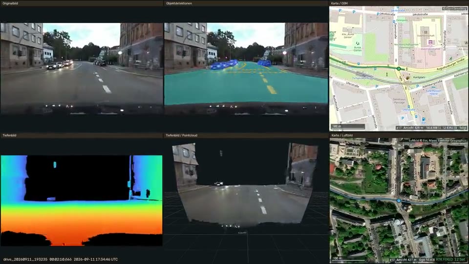
Our test vehicle captures its surroundings all around: with a multi-camera system for three-dimensional capture, a 360° laser scanner, and a surround-view camera. The measurement data is evaluated in the vehicle in real time. During measurement drives in Chemnitz, road users, roadway, traffic lights, and traffic signs are detected, localised, classified, and rated with a measure of reliability. More on this in the project AI-Based Environment Perception for Autonomous Public Transport.
The same technology captures people. A sensor chair with pressure sensors and a camera observe the same movement from two perspectives; their data is merged so that the system reliably recognises what the person is doing at that moment. In the MotionComposer, the recognised movement immediately becomes sound. Here, latency counts alongside accuracy: the feedback must come so quickly that it is experienced as a consequence of one’s own movement.
A sensor that already evaluates while capturing is a smart sensor. When control and actuators are added, the result is a system that acts on its environment independently. Physical AI is our term for AI that works in such systems: in vehicles, automated guided vehicles and mobile machinery, and interactive devices. It must decide in real time, cope with incomplete measurements, and detect the faults of a sensor.
We describe the mathematical foundation for this, state estimation and the parallel tracking of multiple interpretations, under Hybrid AI & Decision Intelligence.
AI Technologies
Image-based and video-based AI, grown out of many years of experience in industrial machine vision.
AI Technologies
Machine learning combined with mathematical modelling, rules, and technical system models – for statements that show how certain they are.
AI Technologies
Analysing spatial information intelligently and combining it with visual and other data.
Solutions
Multi-sensor environment perception for machines that move on their own: automated guided vehicles on the shop floor, mobile robots in manufacturing, and mobile machinery in the field.
Solutions
Detecting, tracking, and understanding people in camera images: position, motion, posture, gestures, and face – with high detection performance and a low false alarm rate.
Industries
Environment perception, sensor data fusion and digital environment models, plus AI support for the software engineering process.
Industries
Motion analysis, contactless interaction and sensor-based assistance for therapeutic and interactive complete systems.
Projects & References
Perception in the vehicle and the digital environment model of the operating area work hand in hand: what the vehicle detects becomes permanently usable knowledge about the environment.
Projects & References
A therapy device that turns physical movement directly into music and sound – contactless and in real time.
Whether a first AI adoption or a complex development task – we discuss the requirements and suitable next steps with you.