AI Technologies
Sensor Fusion & Physical AI
Combining information from different physical measurement sources – camera, radar, LiDAR, and other sensors – as the basis for systems that act in the real world.

AI Technologies
Image-based and video-based AI, grown out of many years of experience in industrial machine vision.
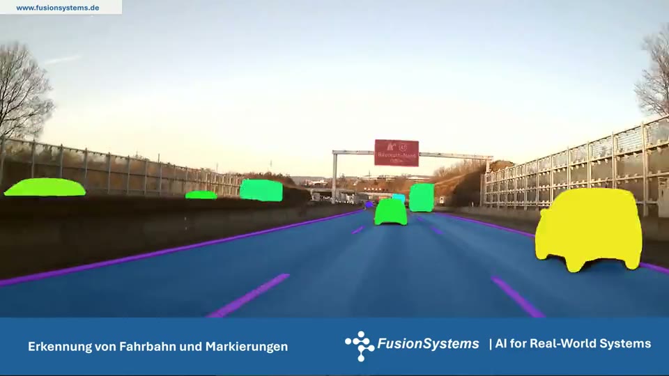
A detection is as good as its training data and the recording conditions. That is why every detection comes with a measure of its reliability. Where a feature can be measured directly, we prefer the measurement to the learned model.
Our experience comes from industrial machine vision and vehicle perception. The same methods a vehicle uses to perceive its environment also analyse aerial images and recognise the poses and movements of people.
For us, classic image processing and machine learning are not opposites. Where a feature can be measured, such as a length, a position, or a shape, we measure. Where appearances are diverse and hard to capture in rules, we use neural networks. Many of our systems combine both: the network finds and outlines the object, the measurement evaluates it.
| Perspective | What is detected | Purpose |
|---|---|---|
| Manufacturing | Cracks, scratches, dents, deviations in shape and dimensions, position of components | Quality inspection in the running process, automatic feeding |
| Road | Roadway, markings, vehicles, persons, traffic lights, traffic signs | Driver assistance, automated driving, maintenance of digital environment models |
| People | Persons, body parts, poses, gestures, fine movements | Therapy and rehabilitation, human-machine interaction |
| Aerial image | Buildings, trees, vehicles, areas, changes | Planning, monitoring, geodata inventories |
A detection in a single image is rarely enough. We consistently track detected objects across the image sequence. This makes the detection stable, reduces the number of false alarms, and additionally provides direction of movement and speed. In person detection, the goal is high detection performance combined with a low false alarm rate.
Machine learning needs examples, specifically from the later area of use. We collect, organise, and version image data and annotate it with our own tools; for aerial images, this is Acotate 2.0 AERO. Automatic pre-annotation speeds up the work; people correct and approve. Where real recordings are missing or too rare, we add synthetically generated images.
Vision-language models evaluate an image together with text. This makes it possible to solve tasks where pure image recognition fails: identifying a weathered traffic sign with the help of the standard description, or classifying a document page by its function. How we use this is described under Multimodal AI.
AI Technologies
Combining information from different physical measurement sources – camera, radar, LiDAR, and other sensors – as the basis for systems that act in the real world.
AI Technologies
Every data source has its strengths and limits. The result becomes reliable when text, images, audio, sensor data, and geodata are interpreted together.
AI Technologies
Analysing spatial information intelligently and combining it with visual and other data.
Solutions
Detecting, tracking, and understanding people in camera images: position, motion, posture, gestures, and face – with high detection performance and a low false alarm rate.
Solutions
Analysing aerial and satellite images with AI, recognising spatial relationships, and turning geodata into concrete insights.
Industries
Preserve experience-based knowledge, manage variants, and use image and sensor data to assess condition and quality.
Industries
Environment perception, sensor data fusion and digital environment models, plus AI support for the software engineering process.
Industries
Motion analysis, contactless interaction and sensor-based assistance for therapeutic and interactive complete systems.
Projects & References
Perception in the vehicle and the digital environment model of the operating area work hand in hand: what the vehicle detects becomes permanently usable knowledge about the environment.
Projects & References
A therapy device that turns physical movement directly into music and sound – contactless and in real time.
Whether a first AI adoption or a complex development task – we discuss the requirements and suitable next steps with you.